
Crossing FAQ
Since 2002, the National Park Service has conducted research on the conservation needs of the Southern California cougar population and other wildlife. The wildlife crossing at Liberty Canyon is based on conclusive findings and an identified need to connect the open spaces that have been preserved through local community efforts over three decades.
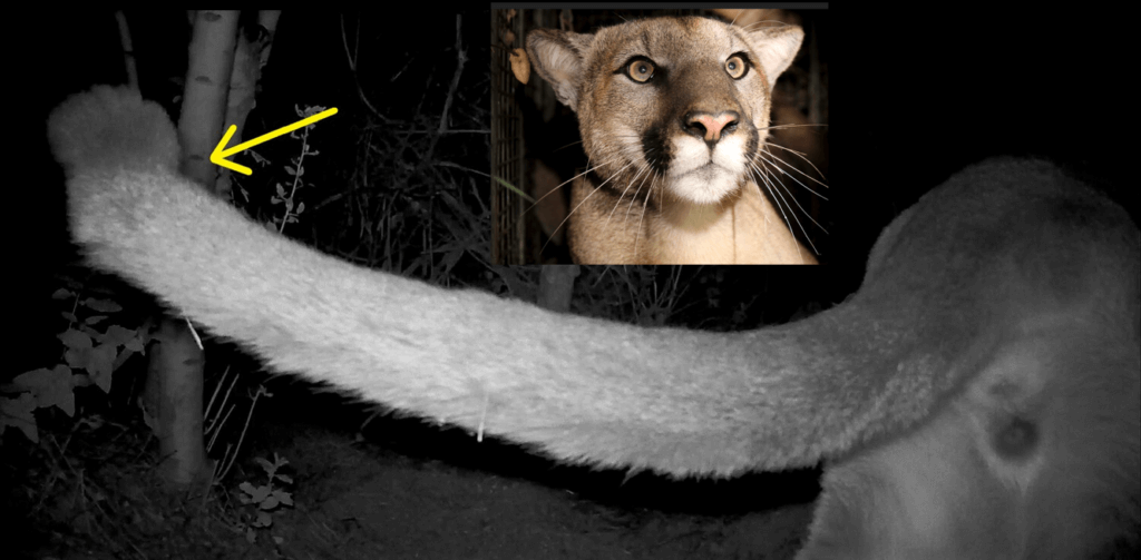
The National Park Service has published extensive research that shows the population is threatened with extinction due to inbreeding within our lifetimes. This is due to a number of factors, none more significant than the loss and fragmentation of habitat by roads and development. This leads not only to deaths from vehicle collisions (to date a total of 32 mountain lions have been struck and killed by vehicles in the NPS study area since 2002), but also multiple cases of first-order inbreeding (e.g., sibling to sibling, parent to offspring) because animals are not able to disperse in and out of the area.
Genetic analyses indicate that lions in the Santa Monica Mountains have among the lowest genetic diversity of any mountain lion population ever documented. The wildlife crossing would provide the connectivity needed to fix this genetic collapse by allowing for the cats living north of the Santa Monica Mountains to travel into the range and for animals living south of the freeway to disperse out of the area.
One study released reaffirmed the importance of the project, noting that the Southern California mountain lion population is nearing an “extinction vortex.” In April of 2020, the California Fish and Game Commission unanimously voted to advance the petition by the Center for Biological Diversity and the Mountain Lion Foundation to declare this population of cougars as threatened under the state’s Endangered Species Act for final consideration—this decision is still pending.
In September of 2020, the National Park Service announced an alarming discovery that further underscored the critical and urgent need for the wildlife crossing—the first physical abnormalities linked to an inbreeding depression in the area mountain lions. “This is something we hoped to never see,” said wildlife biologist Jeff Sikich. “We knew that genetic diversity was low here, but this is the first time we have actually seen physical evidence of it. This grave discovery underscores the need for measures to better support this population.”
The Santa Monica Mountains to the Sierra Madre Range is one of the few coastal inland connections remaining in Southern California and has been identified as a critical corridor in multiple research and planning efforts in order to preserve biodiversity in the region, and ensure ecosystem resiliency given increasing impacts from challenges like climate change and urban development.
The South Coast Wildlands 2008 whitepaper and the California Department of Fish & Wildlife 2010 California Essential Habitat Connectivity Project have both identified the need to preserve and enhance this critical linkage, “as one of the highest priority linkages to conserve in order to sustain ecological and evolutionary processes” in California’s South Coast Ecoregion.
Decades of local, regional and statewide scientific study, research projects, and planning efforts have informed need for a wildlife crossing at Liberty Canyon.
- Research conducted by the National Park Service since 2002 has demonstrated that mountain lions could face extinction in the Santa Monica Mountains within decades because of a fragmented landscape.
- A report published in March of 2018 summarized the recommendations from some of the world’s foremost experts on wildlife connectivity and crossing structures and combines them with landscape characteristics and wildlife data to prioritize locations for wildlife crossings. The experts’ findings noted that the site at Liberty Canyon provided the best location in that region for improving connectivity and an overpass structure the best solution for serving the broadest range of species.
- A report by the U.C. Davis Road Ecology Center identified the 101 Freeway in the area of the wildlife crossing as one of the Statewide Wildlife-Vehicle Conflict Hotspots
- South Coast Missing Linkages: A Linkage Design for the Santa Monica-Sierra Madre Connection 2006, identified this linkage as one of the highest priority linkages to conserve in order to sustain ecological and evolutionary processes in California’s South Coast Ecoregion, in light of existing land use pressures and in the context of climate change.
- This linkage was also identified by the California Essential Habitat Connectivity Project, which was commissioned by Caltrans and the California Department of Fish and Wildlife with support from the Federal Highways Administration in a report California Essential Habitat Connectivity Project “A Strategy for Conserving a Connected California, 2010.”
The development of a wildlife crossing at Liberty Canyon is also in accordance with federal landscape-scale planning efforts such as the following:
- Integrated Eco-Logical Framework (IEF)/Eco-Logical Program, (Transportation Research Board; Release Date: 2012).
- US Fish and Wildlife Service’s Landscape Conservation Cooperatives (Title: California Landscape Conservation Cooperative Science-Management Framework; Release Date: December 2013).
- Western Governor Association’s Initiative on Wildlife Corridors and Crucial Habitat, (Title: Wildlife Corridors Report; Release Date: November 2008).
- Regional Advance Mitigation Planning (RAMP; 2008) in California.
As evidenced from decades of wildlife crossing projects across the world, such as the successful structures in Banff National Park, and the array of animals seen using an overpass in Utah in a recent viral video, wildlife crossings work. As the organization ARC: Animal Road Crossings published in a recent report, “Data collected from studies of crossing structures with wildlife fencing throughout North America indicate up to an 86-97% DECREASE in wildlife-vehicle collisions upon affected roadways.”
The wildlife themselves in many cases figure out these crossings provide safe passage fairly quickly–they will go to great lengths to avoid crossing roadways, and actively seek out safer routes. At a crossing in Colorado, the deer started using it just days after completion; in Washington State, deer attempted to use a crossing before it had even been finished!
Decades of wildlife crossing research has also provided methods we will be utilizing for the Wallis Annenberg Wildlife Crossing to encourage animal use, including exclusionary fencing, which eliminates options, and landscaping and vegetative cues.
For the Liberty Canyon site, we predict the wildlife will use it almost immediately after completion. The location is already a natural funnel from open space north and south, leading animals to the last 1,600 feet of protected space on either side of the freeway. The National Park Service has also documented multiple mountain lions attempting to cross at that location. We will watch with interest to see what species of animal uses it first!
“Agoura Hills is known as the ‘Gateway to the Santa Monica Mountains,’ so it makes perfect sense that our city is the site of the future wildlife crossing. We are honored to serve as
that ‘gateway’ not just for humans, but for our native flora and fauna that will rely on this bridge to survive and thrive.”
Deborah Klein Lopez, Mayor of the City of Agoura Hills
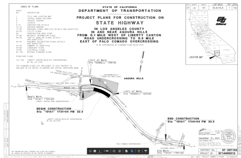
The crossing site is located along the U.S. Route 101 at the Liberty Canyon Road exit, in Agoura Hills, California.
The 101 freeway is a heavily travelled commuter route that serves the Greater Los Angeles area; connects Los Angeles and Ventura Counties; and acts as the primary access route to and from downtown Los Angeles, various residential communities, and tourist destinations in Los Angeles, as well as the central California coast. This location is a formidable and virtually impenetrable barrier for many wildlife species including mountain lions, bobcats, gray foxes, coyotes, and mule deer that inhabit the Santa Monica Mountains, the Simi Hills, and the Santa Susana Mountains – over 300,000 cars pass through this freeway site daily.
Of all the area roads, multiple research and planning efforts have identified the 101 Freeway as the most significant barrier to the ecological health of the region, and contributes to a probable extinction vortex. A crossing site assessment by experts from across the world was released in 2018 that reviewed potential sites along the 101 Freeway as part of a linkage analysis—the experts agreed the Liberty Canyon location was the best option to reconnect this vital corridor and an overpass the best solution. As a primary condition for success of any wildlife crossing is having protected space on both sides, this location was the only viable choice in some respects—it’s the last 1,600 feet of adjacent protected space north and south of the freeway in the area.
As the organization ARC: Animal Road Crossings published in a recent report, “every year in the United States, there are 1-2 million wildlife-vehicle collisions that cause, 200 human fatalities, 26,000 injuries, and cost $9.7 billion.” The costs of collisions to society often outweigh the costs of building wildlife crossing structures. Placing structures along road segments with as few as 5.1 deer collisions per mile per year creates net benefits.”
Additionally, according to the sixth annual Wildlife Vehicle Conflict report from the Road Ecology Center at the University of California, Davis, wildlife collisions are a public safety issue. California drivers lost about $232 million to costs (these costs include the expense of vehicle damage, injury treatment and recovery, emergency response, lost work, loss of the wildlife and other costs) associated with wildlife-vehicle conflicts in 2018 and over $1 billion since 2015. The report also found records of ~7,000 reported accidents per year on California highways involving deer and other large wildlife. Colorado, Wyoming and other states have implemented wildlife crossings and other state-led solutions that cut mortality at key collision sites by as much as 95 percent.
The scientific inquiry, evaluation and planning that led to this design was quite extensive, and involves, and continues to involve, some of the top experts in the world on wildlife crossings along with input of the five main project partners: Caltrans, the National Park Service, the Santa Monica Mountains Conservancy/MRCA, Resource Conservation District of the Santa Monica Mountains, and the National Wildlife Federation.
A feasibility study by Caltrans was conducted in 2015 that evaluated other alternatives, and a crossing site assessment by experts from across the world was released in 2018 that reviewed potential sites along the 101 Freeway as part of a linkage analysis—the experts agreed the Liberty Canyon location was the best option to reconnect this vital corridor and an overpass the best solution.
In 2018, the environmental document was released with a 30% design plan developed by Caltrans and the Resource Conservation District of the Santa Monica Mountains. Since none of the project partners had designed or built a wildlife crossing of this scale and magnitude, in order to ensure the design and engineering of this landmark crossing was guided by the best available science we consulted with some of the world’s foremost experts on wildlife connectivity and crossing structures.
In 2019, we began collaborating with ARC-Animal Road Crossings, an interdisciplinary partnership working to facilitate new thinking, methods, materials and solutions for wildlife crossing structures. In May of 2019, the National Wildlife Federation hosted ARC and its partner the Ecological Design Lab, to conduct an integrated design workshop for project partners, key stakeholders, local residents, scientists, elected officials, and members of the Native American community. In June of 2021, ARC also conducted an additional technical review at the 95% designed milestone.
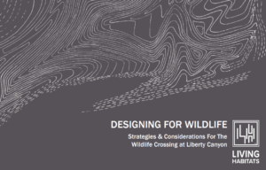
As a recommendation from the 2019 workshop, the partners conducted a RFP process and selected a world-renowned team led by a landscape architectural practice, Living Habitats LLC, to provide a design guidance report for the final design and engineering stage of the project—they produced an extensive 200-page book, “Designing for Wildlife: Strategies and Considerations for the Wildlife Crossing at Liberty Canyon,” which helps guide design decisions for the project team. Using a science-based strategy and an integrated design approach, Living Habitats has been working with Caltrans and the project partners on every aspect of the design planning process and is also helping to monitor construction.
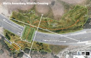
Yes! The Wallis Annenberg Wildlife Crossing is the world’s largest wildlife crossing. It consists of two structures:
- The 101 Freeway structure: 250 ft x 174 ft (43,500 sq ft)
- The Agoura Road structure: 71 ft x 175 ft (12,425 sq ft)
- Combined total: 55,925 sq ft
The full project spans approximately 800 ft north to south and 1,250 ft east to west, transforming nearly 13 acres in total.
You may have seen recent headlines claiming that Colorado’s I-25 Greenland Wildlife Overpass holds the world record. That project measures 200 ft x 209 ft (41,800 sq ft) — impressive, but smaller than the Annenberg crossing when its full scope is considered, including both structures and approach slopes.
It’s worth noting that the two sites are quite different in complexity. The Annenberg crossing spans ten freeway lanes plus an access road, and required design solutions for steep slopes, a creekbed, heritage oak trees, and a major multi-agency utility relocation.
As landscape architect Robert Rock puts it, it’s a healthy rivalry — and both crossings will have an enormous impact on wildlife.
Once built, it will be the largest wildlife crossing in the world of its kind. There are some nuances to how you define that, but that is the phrase we have fact checked. It is also the first to be done of this scale in an urban area.
It will span ten lanes of pavement, or eight lanes of traffic. So, both numbers are correct. The other two lanes are breakdown lanes. Caltrans uses the “ten lanes of pavement” to denote traffic plus breakdown lanes.
As part of the feasibility study, planning and environmental review for our project, a tunnel was eliminated from consideration as a solution as it does not provide for a fully connected ecosystem and not all wildlife will use a tunnel. The goal of the Liberty Canyon crossing is to reconnect an entire ecosystem in the middle of one of the world’s biodiversity hotspots, and allow for connectivity of flora and fauna, as well as save the local mountain lion population.
A tunnel would also have been more expensive given some original Caltrans estimates, as you cannot drill the needed size given the distance, and Caltrans would have had to perform a “cut and cover,” which uses excavation equipment to dig a trench and then cover it with concrete. To do this would have required the 101 Freeway—one of the busiest freeways in the world—to close for a period of time. We think everyone in the Los Angeles area would agree this isn’t feasible nor desirable!
We lead with the science. We are not trying to build the world’s largest wildlife crossing because we want to be ambitious, we have to build the largest in the world because that’s what the project requires to be successful. We would gladly build the smallest crossing in the world, yet we don’t have the ability to shrink the 101 Freeway. What first and foremost dictates the size of the crossing is it has to cover ten lanes of pavement over the 101, along with Agoura Road. Crossing science also has shown that for every foot long a crossing needs to be, the width needs to increase to make the landscape appear inviting to wildlife—a narrow passageway across the freeway would deter animal movement.
Crossings have different factors that drive design, and are all site specific, and the Liberty Canyon crossing is not comparable with others. Factors that drive our design are things like the slope at our location, the size of the freeway, the urban setting and traffic.
For example, many existing wildlife crossings are located in areas with average traffic of less than 10,000 cars per day. Parleys Summit receives an average of 10,000 cars per day. Liberty Canyon gets over 300,000 cars a day and is one of the busiest roadways in the world. We have to mitigate for impacts others do not, like extensive sound and light pollution, which influences the design. We have to add sound walls for example, where other crossings might not have such considerations.
We also have only one site where we can location this crossing—it’s the last 1,600 feet with protected space on both sides of the freeway in the area, and this site, from an engineering and design perspective, is not ideal and requires additional considerations that also add to the cost like grading and sloping. We also have to relocate utilities, which increases the expense as well.
Additionally, most other crossings are trying to solve a roadkill problem. Parleys Summit was nicknamed “slaughter alley,” for example, because of the excessive number of wildlife-vehicle collisions. By contrast, we do not receive a comparable amount of animal deaths at Liberty Canyon given most animals abandon attempts to cross given the formidable barrier the 101 presents. Our main project goal is reconnecting an entire ecosystem, for both flora and fauna, to solve for genetic isolation and to prevent the extinction of a mountain lion population, which requires a biological focused design rather than one just developed for conveyance. And this contributes to design, scope and cost—for example, just adding the needed soil base alone to create a living habitat adds significantly to the load requirements for the structure.
Unlike a traditional freeway overpass, the crossing will support wildlife and provide the habitat, shelter, food and water that individual species need to thrive. To achieve this, the top of the structure will be covered in nearly one acre of native vegetation. The wildlife crossing will connect native chaparral and coastal sage scrub to the north and south by providing an addition of over ten acres of habitat restored as coastal sage scrub and oak savannah.
Yes! With the help of Caltrans and the National Park Service, Living Habitats started collecting seeds, acorns and mushrooms over a year ago. In 2022, a special project nursery was built, where much of the plants will be grown. These will be planted on the site allowing the habitat to grow vegetation naturally throughout the site from the soil up and retaining the critical local genetic material. Native oak and willow trees sourced from the site will also be planted and ten acres of space along the two adjoining slopes where the wildlife crossing will be built, will also be improved.
We are also restoring the native vegetative community to a project site that has experienced both a reduction in biodiversity as well the onslaught of non-native vegetation that represents an increase in the potential fuel load for future wildfire. These invasive species are being removed within the project footprint and are being replaced with an array of native species, restoring and improving the health of the ecosystem. In addition, the project includes cutting-edge solutions for restoring biological health to the soils on the site through the collection of mycorrhizal fungi and the preparation of native inoculum for reintroduction into the constructed landscape.
The site grading and vegetative strategies will replace several acres of invasive grasses and will serve to improve the overall health of the ecosystem as well as protect against surface erosion and impacts to the existing waterways.
During the public engagement process, the community heavily supported planning that would allow wildlife every opportunity for safe passage, and it was decided that there would be no trails or public access. However, the crossing will be seen along the recreation trails that are in the area, and a viewing platform will be built to facilitate optimal viewing, too.
We have consulted with fire officials, (and fire safety is a part of any Caltrans project) and have been advised the wildlife crossing poses no additional risk in terms of wildfire spread. Fire can easily jump a half a mile or more, indeed, the Woolsey Fire crossed the 101 Freeway right at the crossing location and burned the entire site, demonstrating you don’t need the crossing for a fire to jump the freeway.
The crossing project will actually help with fire safety as we are restoring native vegetation on and around the crossing—currently, the project area is mostly non-native mustard, a plant that poses more of a fire risk than native grasses. And on the south side, we funded the undergrounding of electrical transmission lines, which also reduces fire risk.
“This is a huge step forward. Not only will Liberty Crossing be the largest wildlife crossing of its kind in the world, it is emblematic of the bold and creative solutions we need to protect California’s wildlife as our state continues to grow. Nature-based solutions like Liberty Crossing are also essential for combatting the climate crisis and our work to conserve 30 percent of California’s land and coastal waters by 2030.”
Wade Crowfoot, California Secretary for Natural Resources
The wildlife crossing will connect native chaparral and coastal sage scrub habitat to the north and south of the 101 Freeway by providing an addition of over ten acres of habitat. As climate change brings additional pressures to California and the Santa Monica Mountains, both flora and fauna require options in order to persist and adapt to rapidly changing conditions. Reconnecting an ecosystem long fragmented will significantly help mitigate the increasing challenges wildlife and plants face with from a changing climate.
The South Coast Wildlands 2008 whitepaper and the California Department of Fish & Wildlife 2010 California Essential Habitat Connectivity Project have both identified the need to preserve and enhance this critical linkage, “as one of the highest priority linkages to conserve in order to sustain ecological and evolutionary processes” in California’s South Coast Ecoregion, due to existing land use pressures and climate change. The wildlife crossing will also add native vegetation to the landscape, which will help reduce greenhouse gases. In addition, the preservation of biodiversity in the Santa Monica Mountains will reduce greenhouse gases by maintaining substantial, healthy vegetative cover in this area.
“The Wallis Annenberg Wildlife Crossing bridges landscapes, boundaries and disciplines: it is a project of hope that connects people to nature with new, innovative infrastructure, and integrates engineering, ecology and landscape architecture for a sustainable future. In doing so, the Crossing catalyzes a system to reweave California’s significant, biodiverse and
protected landscapes, for people and wildlife — and sets a new standard for reconnecting landscapes worldwide.”
Nina-Marie Lister, Professor & Director, Ecological Design Lab at Ryerson University & ARC Partner
“To break ground for the Wallis Annenberg Wildlife crossing is to launch an exciting new class of green infrastructure for biodiversity. Not only will it cross one of the largest and busiest highways in North America, but it will do so with close attention and respect to the protected landscapes on each side of the highway that ensure its success. Its design is the ideal blend of structural and natural design and it will serve not just as a crossing for wildlife but as an inspiration to the world that we can build well for nature and our shared future.”
Jeremy Guth, Conservation Director, the Woodcock Foundation & Founding Partner and Steering Committee Member, ARC Solutions
Indeed, wildlife crossings are nothing new, and the Wallis Annenberg Wildlife Crossing benefited from decades of science, design and experience from crossings around the world. Yet it is also a landmark crossing in many ways, such as the densely populated location, the unprecedented research, the project goal of saving a population of animals threatened with extinction and reconnecting a regional ecosystem, the integrated design, and the significant public-private partnership.
The Wallis Annenberg Wildlife Crossing is the first to attempt such a large-scale intervention for wildlife in such an urban setting — the greater Los Angeles metropolitan area is the most densely populated area in the United States and is home to 20 million people.
The National Park Service research that led to discovering the need for the crossing is groundbreaking as well—thought to be one of the longest running studies of urban carnivores. Since 1996, NPS biologists have researched carnivores and other local wildlife in the Santa Monica Mountains and the surrounding region. The project began right in the Liberty Canyon area, with the tracking of bobcats and coyotes, and it expanded to include mountain lions in 2002. Overall, the research has focused on urbanization and habitat fragmentation in wildlife communities. The study will continue to provide landmark science for urban wildlife conservation that will help inform future efforts worldwide.
Additionally, the project goals differ from many other crossings, which are trying to solve a roadkill problem. By contrast, Liberty Canyon is not the site of as significant an amount of animal deaths by vehicles as other projects, as most animals abandon attempts to cross given the formidable barrier the 101 presents. Our main project goal is reconnecting an entire ecosystem, for both flora and fauna, to solve for genetic isolation and to prevent the extinction of a mountain lion population, which requires a biological focused design rather than one just developed for conveyance. The 101 Freeway isolated the entire Santa Monica Mountains from the rest of the world for the first time in its evolutionary history. We can find no precedent of a crossing designed to reconnect an entire regional ecological system.
The design reflects a wholescale ecosystem approach, which is also not typical for the majority of crossings. While the physical bridging structures serve as the keystone element, the full project embraces a comprehensive design solution that leverages multiple facets of scientific research, sustainable principles, and best practices in support of an ecologically vibrant and resilient solution for regional habitat connectivity. As the team at ARC: Animal Road Crossings, wrote as part of their technical design review in 2021:
“Where this project really excels, is the treatment of the landscape surface as a set of specifically designed and integrated ecosystem types that reflect the native plant communities and habitats that create a draw for the target species. In this way, it’s critical to appreciate that the landscape surface is not “surface decoration” or an add-on, but rather is integral to the ecological functioning of the crossing design as a system – and to its success.
This project area extends far beyond the crossing overpass structure, encompassing an
ecological design effort impacting eight acres of the surrounding landscape. The scale and magnitude of this endeavor should be highlighted as it further emphasizes the singular and extraordinary nature of the Liberty Canyon project in advancing connectivity and wildlife conservation across urbanized landscapes.”
The Wallis Annenberg Wildlife Crossing is a public-private partnership of monumental scope that has leveraged the expertise and leadership of dozens of organizations and institutions from across the state, country, and the world. The work of the Liberty Wildlife Corridor Partnership serves as an international model for collaborative solutions for wildlife in the transportation sector, including the role of private philanthropy. The invaluable contribution of Wallis Annenberg and the Annenberg Foundation in bringing their leadership in philanthropy to this project cannot be overstated. Their donation of $26 million dollars—the largest private contribution to a wildlife crossing to date—helped us leverage public funds and inspired the additional giving needed to reach the finish line.
The Wallis Annenberg Wildlife Crossing is also inspiring efforts to improve connectivity across California, the United States and the world. As Louis Sahagún wrote in an article about the crossing for the Los Angeles Times, “Future historians may look back on the second decade or so of 21st century American architecture as the Age of Wildlife Crossings. Congress in November passed a national infrastructure package that for the first time sets aside $350 million in federal funding for wildlife crossings to reduce wildlife-vehicle collisions in all 50 states.”
“Wildlife crossings restore ecosystems that had been fractured and disrupted. They reconnect lands and species that are aching to be whole. I believe these crossings go beyond mere conservation, toward a kind of environmental rejuvenation that is long overdue. It’s a model for the kind of public-private partnerships that can heal our environment for the long haul. Thanks to this extraordinary commitment, California is now in the vanguard of that change.”
Wallis Annenberg, Chairman, President, and CEO of Annenberg Foundation
P-22 made a miraculous journey and crossed two of the busiest freeways in the country to make a home in Los Angeles’ Griffith Park, where he roamed under the Hollywood sign from 2012 until his death in 2022, coexisting peacefully with neighbors and the over 10 million visitors a year, and remaining largely unseen as befitting his species nickname, “ghost cat.”
His moniker originated from the National Park Service’s scientific naming system– P stands for Puma, which is just another name for mountain lion like cougar or panther, and his number means he was the 22nd cat collared in the National Park Service study (they are now up to over 100). You can learn about P-22 and the other cats in the study at https://www.nps.gov/samo/learn/nature/puma-profiles.htm
During his lifetime, he was the first mountain lion to have been sighted there many years. At eight square miles, P-22’s home range was the smallest ever recorded for a male mountain lion—on average, adult males possess ranges of 100-200 square miles.
In May of 2024, a new mountain lion was spotted in Griffith Park. His stay proved short, sadly, and it was believed he was hit by a car on the 405 in July of 2024.
“Truly, it’s something to celebrate that the city that gave us Carmageddon also has allowed a mountain lion to thrive. Los Angeles now needs to prove to P-22 his journey wasn’t for naught. Let’s give him—and all his Santa Monica Mountain kin—a Hollywood ending by building the largest wildlife crossing in the world in one of the largest urban areas in the country. He deserves as much.”
Beth Pratt, from When Mountain Lions Are Neighbors
He was the ultimate cougar influencer! People across Los Angeles and around the world rallied around his inspiring story—he was a mountain lion hero! His story was featured in The New Yorker, Wall Street Journal, Los Angeles Times, National Geographic, CBS News, BBC World News, NPR, Men’s Journal, 60 Minutes, the book When Mountain Lions Are Neighbors, a museum exhibit, and a documentary film, The Cat That Changed America. His story fueled a new conservation movement, showing that wildlife and people can coexist in mutual wonderment. He also inspired the building of the Wallis Annenberg Wildlife Crossing. Not bad for a small-town cougar!
P-22’s magical journey changed a lot of minds, both scientifically and philosophically. His plight as a lonely, dateless, bachelor, roaming the Hollywood Hills, and cut off from the rest of his kind, inspired a new paradigm in conservation. When the number-one threat to wildlife worldwide is loss of habitat, we can no longer think of our cities or towns or neighborhoods, or even our backyards, as exempt from the natural world—or as off-limits to wildlife. We need to expand our view and realize that our shared spaces are as essential to conservation as our traditional protected lands. We need to create a new model of suburban and urban wildlife refugia. And P-22 showed us this was possible, even with a large predator. If LA can coexist with a mountain lion, for instance, then what excuse can any other city offer for not making way for monarch butterflies?
Moving wildlife in general, and for mountain lions in particular, doesn’t go well – they try to get back, and often die. Relocating the mountain lions to “wilder” areas is also risky, there is no mountain lion Shangri-La—where there is viable mountain lion territory in California, there are already mountain lions. Relocating a mountain lion to new place will result in the death or displacement of one of the animals, as they do not share territory, and will sometimes fight to the death over it. P-22 might have even tried to return to Griffith Park if relocated, as it is his home, which could risk his safety.
As for playing matchmaker and bringing him a girlfriend, Griffith Park was too small for more than one mountain lion. Blind dates for mountain lions don’t always go so well, and setting up a match would also be risking the safety of the female cat.
P-22 lived to be an estimated 12 years old, which is longer than most wild male mountain lions live. In the fall of 2022, he started behaving abnormally and appeared to display some signs of illness in photographs. The biologists captured P-22 and brought him in for a health evaluation. Sadly, this evaluation revealed serious health issues: stage two kidney failure, a weight of 90 pounds (he normally weighed about 125), head and eye trauma, a hernia causing abdominal organs to fill his chest cavity, an extensive case of demodex gatoi (a parasitic skin infection likely transmitted from domestic cats), heart disease, and more. The most severe injuries resulted from him being hit by a car before his capture. As a result, the difficult decision was made to humanely euthanize P-22.
On December 17, 2022, the world said goodbye to P-22. His tragic passing served to unite people around the globe in a collective mourning. Angelenos, bereft at losing their “king,” erected makeshift memorials in Griffith Park at which adults and children alike left heartfelt messages and flowers. The marquee of the famous Mohawk Bend bar on Sunset Boulevard read “Rest in Puma, P-22,” and the Los Angeles Public Library system issued a limited-edition library card in his honor.
Millions of people posted reactions online, expressing grief and showing compassion for the lonely and heroic cougar who meant so much to so many. Governor Gavin Newsom shared that he “grew up loving these cats”; Hilary Duff wrote commented on Instagram that “P-22 = Icon”; and Rainn Wilson tweeted, “RIP to P-22, a gorgeous LA icon.” Media outlets as diverse as Rolling Stone, CNN, the Economist, NPR, and Buzzfeed featured stories about his passing, and on the day he died, P-22 was trending on Twitter, which we’re guessing is the first time in history that a wild mountain lion has taken over the Internet.
His Celebration of Life event at the Greek Theatre (which sold out in two hours and crashed the Ticketmaster website) featured appearances by the DJ and songwriter Diplo, actors Rainn Wilson and Julia Butters, Congressman Adam Schiff (“I had the honor of representing P-22 in Congress”), and more high-profile figures from the community. Offspring of the original members of the band Tthe Tokens, who popularized “The Lion Sleeps Tonight,” led the six thousand people in attendance—many sporting “I Heart P-22” shirts—in a stirring rendition of the song.
Read Beth Pratt’s Eulogy to P-22 at: https://savelacougars.org/a-eulogy-for-p-22-a-mountain-lion-who-
changed-the-world/
P-22 was been laid to rest in the Santa Monica Mountains, a collaboration between local Indigenous partners, the California Department of Fish and Wildlife, the Natural History Museum of Los Angeles County, and the National Park Service Santa Monica Mountains National Recreation Area. The burial location will not be revealed in order to protect and preserve the site.
Even after his passing, his famous social media channels continue!
Facebook: https://www.facebook.com/p22mountainlionofhollywood
Twitter: https://twitter.com/P22ofHollywood
Instagram: https://www.instagram.com/p22mountainlion/?hl=en
TikTok: @officialp22mountainlion
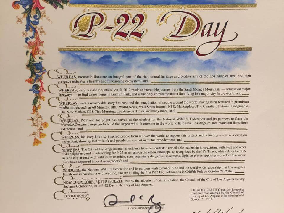
In P-22’s honor, the City of Los Angeles declared October 22 as the official P-22 Day, and a festival in Griffith Park celebrates our hero mountain lion every year, even after his death.
NWF’s #SaveLACougars work goes beyond the usual scope of a conservation project –connecting people with wildlife is another important goal of our campaign benefitting all Angelenos by strengthening our connection to wildlife. We engage in extensive education and outreach efforts, including our annual P-22 Day Festival and Urban Wildlife Week.
We work with our partners to empower people of all ages and backgrounds to play a role in taking care of our ecosystem. The annual culmination of our on-going work is the P- 22 Day Festival & Urban Wildlife Week – the premier events for #SaveLACougars in the Los Angeles area, including specific outreach through the Wildlife 2 Watts program, with thousands of individuals attending each year and over a million reached virtually. The work we do within urban communities is strengthened by these partnerships and directly impacts our joint ability to educate and empower people to act on wildlife conservation efforts.
In 2024, more than 15,000 Angelenos attended and celebrated the beloved at the 9th annual festival. Be sure to attend the 10th annual Festival on October 19, 2025!
For more information on the events, visit https://savelacougars.org/urban-wildlife-week/
“The Wallis Annenberg Wildlife Crossing campaign has sparked a conservation movement by making the plight of our local pumas a global conversation. The success of this project is proving that big cities like Los Angeles have nature that is unique and worth protecting. As someone who grew up in this region, this unprecedented investment in habitat connectivity will not only create a critical connection for pumas and local wildlife but this high profile crossing will connect historically excluded communities to local nature for many generations to come. We are enabling the world to redefine where nature exists and why urban areas deserve more conservation attention.”
MIGUEL ORDEÑANA Wildlife Biologist & Community Science Manager, Natural History Museum of Los Angeles County